FIRST WARN FORECAST: Light snow Monday night/Tuesday morning, bigger concerns Wednesday
KANSAS CITY, Mo. (KCTV) - Super Bowl Sunday evening looks cool and crisp, but quiet! GO CHIEFS! Our temperatures through the end of the game will dip into the 20s. Overnight lows drop into the lower 20s for Monday morning out the door. The weather pattern becomes filled with winter features this week, with accumulating snow likely at times as well as cold air. There are multiple different systems that we will detail below.
ROUND 1:
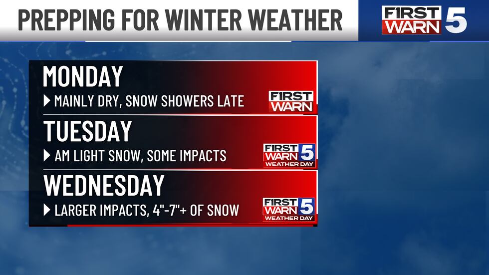
As expected, this first round of winter weather will be a bit less significant. A First Warn is in place on Monday, mainly for snow showers possibly late. Generally, Monday looks to be mostly dry with a good deal of cloud coverage. A broken winter system brings some off-and-on snow showers late Monday into early Tuesday morning. While we could have a few hours of light to moderate snow, the overall impacts will be minor to moderate. With the newest information coming in, we are thinking that a trace to 1 inch of snow looks to be the most likely scenario with this first wave. This is a cut in snow totals, but we did leave our First Warn Weather Day in place for Tuesday morning due to still having measurable snow and potential travel concerns. While numbers are lower, we still think some slick spots are on the table for the Tuesday AM commute. Bigger impacts to follow Wednesday.
ROUND 2:
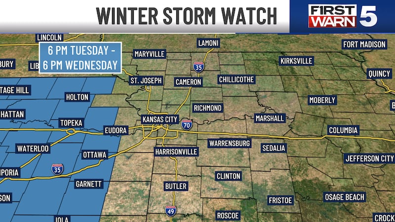
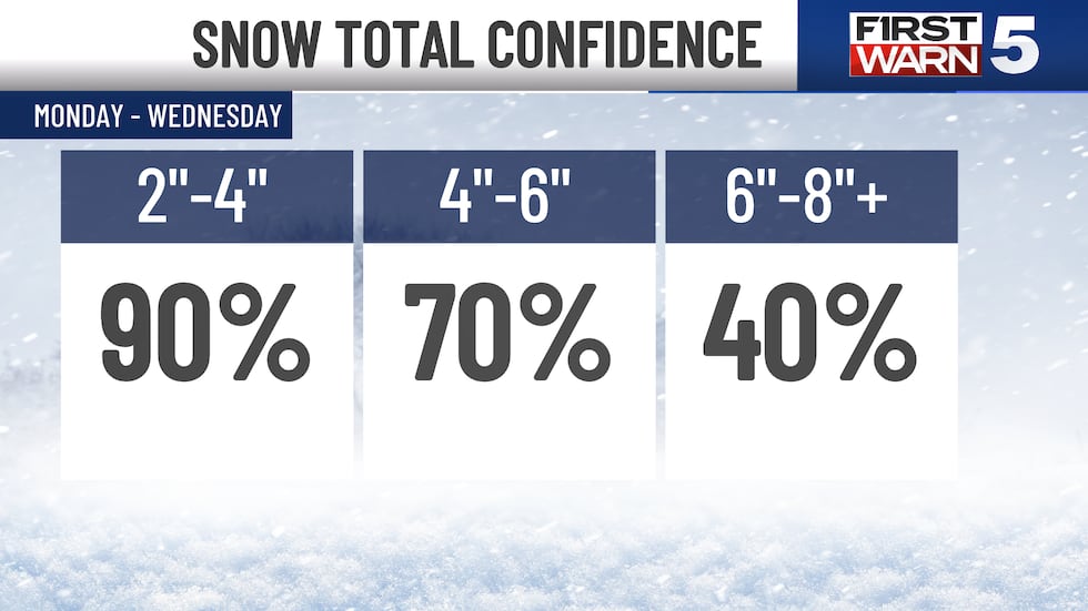
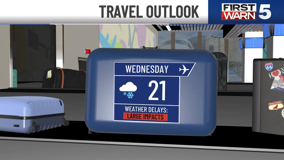
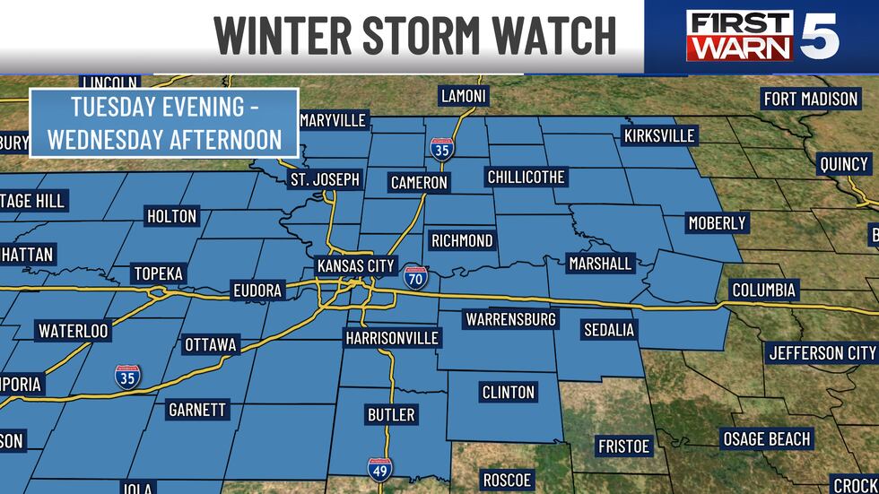
After the small system comes through Monday night/early Tuesday, a much larger winter storm is quick to move in Tuesday night and all of Wednesday. This specific storm is much larger and will be impactful on travel and daily routines. There is a Winter Storm Watch in place for Douglas, Franklin and Anderson counties for all of Wednesday until 6 PM. More counties will get added sometime Sunday night. We will be cold enough for all the snow with this one. Most people in the KCTV viewing area will have a good shot at 4″-7″ of snow by the end of the day Wednesday. Some locations might even see higher numbers. If you have travel plans on Wednesday, please think about an alternative option. Thursday looks to be the best choice, but Tuesday afternoon could be okay as well. With cold temperatures working into the storm, fine and powdery snow is looking more likely. We should keep measurable snow falling into Wednesday evening before this storm moves out Wednesday night. Cold air is expected with highs only in the lower 20s Wednesday, but wind chills will be in the single digits, and even dip below zero Thursday morning.
ROUND 3:
This is our newest First Warn in the forecast. We are beginning to see a larger storm system taking shape for next weekend. Saturday could start with a light wintry mix, but we should pull in cold enough air for more snow showers. Details on totals are less clear since this is still a week away. We will watch this one closely.
With multiple waves of winter weather on the way, temperatures will stay pretty cold. Through the next seven days, highs will only be in the 20s and 30s, well below normal for this time of year.
Copyright 2025 KCTV. All rights reserved.


