FIRST WARN FORECAST: New First Warn for Friday storms, Easter Weekend packs downpours
KANSAS CITY, Mo. (KCTV) - We have been watching this bumpy stretch of weather into the weekend all week, and we have been First Warning for a rainy Easter Sunday since last weekend. New information has brought a fresh First Warn for Friday due to an increased risk for severe storms, and a soaking weekend remains a good bet. Here’s the latest...
THIS EVENING: Warm 70s and windy, with south gusts up to 40 mph at times. Any risk for severe weather has been trimmed north of our area, which is a new update and a positive one.
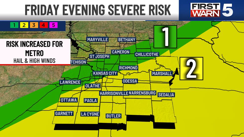
FRIDAY: First Warn for the possibility of strong to severe late-day storms. The morning will be dry and warm with mid-60s. Patchy showers may by near lunchtime, but these will be brief and light. Much of the afternoon will be dry with highs in the low 70s and northwest winds at 10-20 mph. Be aware that by 6 pm, strong storms are expected to develop in the area. A Level 2/5 severe risk has been nudged into the metro, increasing our risk from previous forecasts. The main threats are hail and high winds. That said, the greatest chance for storms remains south and east of Kansas City... but it’s a close call. Those of us south and east of the metro should anticipate a good chance for thunderstorms into the evening, a few of which could be severe.

SATURDAY: First Warn for off and on showers that will impact outdoor plans at times, but we still mix in some dry hours. Much cooler with highs in the upper 50s. Rain is possible at any time of the day, it just doesn’t look to be persistent all day.
EASTER SUNDAY: First Warn for downpours much of the day. It may not be a total washout, with a chance for dry patches at the very beginning and very end of the day. But, overall, we look to see widespread and persistent rain most of the day. It will be cool with highs in the 50s, and winds may kick up to 40 mph at times (especially late in the day).
NEXT WEEK: Quieter overall with warmer 70s returning. Low rain chances for Tuesday, Wednesday, and Thursday. Of those three days, Wednesday is the only one that currently has a chance to bring anything widespread.
Copyright 2025 KCTV. All rights reserved.


