FIRST WARN FORECAST: Wednesday is hottest day in 7 months, plus a new First Warn for when rain returns
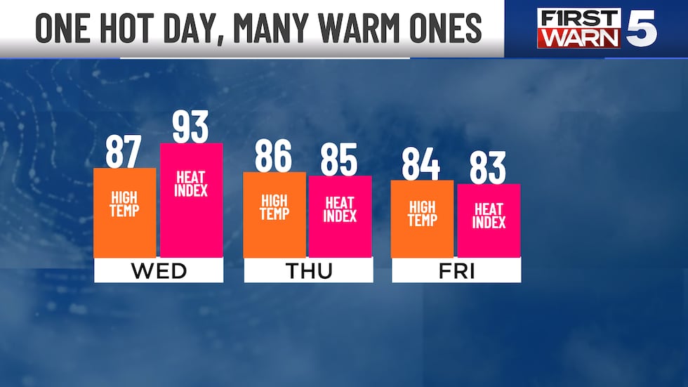
Wednesday’s early taste of summer has been all the buzz lately, and it will bring our first true taste of summer-like heat for the year. The afternoon high of 87 exactly matches the normal high for July 4th. It will also be the hottest day so far this year, and the hottest since October of last year. Humidity will rise sharply, bringing the heat index up to the low to mid 90s. We also need rain, and we have added a new First Warn to next week as showers and storms return.
WEDNESDAY: The morning starts in the low 60s, but the day warms very rapidly to the upper 80s or low 90s. The record for KCI is 91, which we will likely fall short of by just a few degrees. Humidity will be noticeably higher, so the peak heat index will be in the low to mid 90s. Mostly sunny with southeast winds at 10-15 mph. Gusts may reach 30 mph at times.

THURSDAY: Windy, warm, and much less humid. Afternoon highs in the mid-80s, but feeling much less-hot than Wednesday. West winds at 15-25 mph, though gusts could hit 40 mph. Mainly sunny.
FRIDAY: Highs in the mid-80s with a 30% chance for showers or a few thunderstorms. These will be brief and very patchy, so many of us will miss them. The timing for any rain will be early to mid afternoon.
THE WEEKEND: Highs in the low 80s both days and mainly sunny. Saturday will be dry and mostly sunny. Sunday has a rain chance at 30%, though odds point to most of it staying south of the KC metro during the day at this point. Rain fills in more late Sunday night.
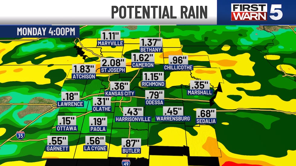
NEXT WEEK: FIRST WARN for Monday as showers and thunderstorms are likely. A few may be on the strong side. Highs will be in the low 80s, with Tuesday a bit cooler with upper 70s. Tuesday also has a rain chance, though it may be focused just east of the area.
Copyright 2025 KCTV. All rights reserved.


