Kansas storms produce several tornadoes, extensive damage confirmed in Grinnell
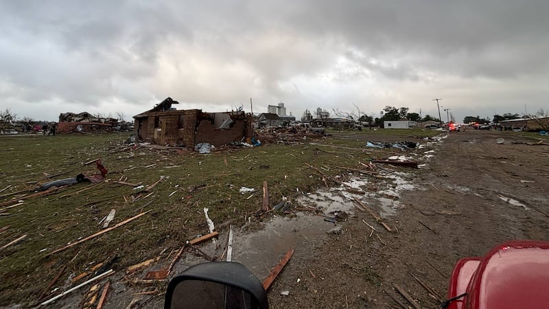
WICHITA, Kan. (KWCH) - A night of severe weather in Kansas produced several tornadoes, one of which caused extensive damage in the Gove County community of Grinnell. Photos from the storm’s aftermath show destruction and damage to several structures, including homes and outbuildings. The tornado even blew the roof off of the Catholic church in Grinnell. There were also downed power lines that caused closures on Interstate 70, eastbound from Colby to Grinnell and westbound from Hays to Grinnell.
Greensburg, Scott City, St. Francis and Pratt were also threatened by tornadoes on what was by far the most active night for Kansas severe weather so far in 2025. Looking ahead, Monday brings more severe storm chances before the weather pattern settles.
Beginning early Monday morning, 12 News will have crews in Grinnell to cover the storm’s aftermath and see firsthand what the tornado left behind.
You can recap the activity from Sunday night as storms fired up and advanced in the updates below.
11:50 p.m.: The tornado warning continues for Reno County with a tornadic storm that prompted a tornado emergency for the small community of Plevna, about 26 miles south and west of Hutchinson.
Numerous counties, largely across northwest, north central and central Kansas remain in tornado watches until midnight or 1 a.m.
11:30 p.m.: A tornado warning is issued for western Reno County until midnight. At about 11:20 p.m., there was a confirmed tornado near Preston, moving northeast at 35 mph. Preston is about 43 miles southwest of Hutchinson.
11:05 p.m.: The tornado warning impacting Pratt County now includes Stafford County with confirmation of a large tornado near Iuka, moving northeast at 40 mph. Iuka is about nine miles north of Pratt.
11 p.m.: The lone tornado warning is now for Pratt County for a thunderstorm capable of producing a tornado. This storm, near Cullison, is moving east at 20 mph.
Following the prior report from this storm and a large tornado near Greensburg, 12 News spoke with the Kiowa County Sheriff’s Office, which reported power lines down at highways 183 and 54, going south and that the Kansas Department of Transportation was going to close the roadway there.
Late Sunday night, crews drove along the path of the storm to assess damage. There were no widespread damage reports in Greensburg or Haviland.
10:30 p.m.: The state’s lone tornado warning remains in effect for the large tornado confirmed in Kiowa County. At 10:20 p.m., the tornado was located near Haviland, moving northeast at 25 mph. The tornado warning until at least 11 p.m. is in effect for Kiowa, Pratt and Edwards counties.
10:15 p.m.: The tornado confirmed in Kiowa County prompted a warning that now includes Pratt County. The tornado was last spotted nine miles south of Greensburg, moving northeast at 45 mph.
From earlier in the evening, the emergency manager covering Cheyenne County relayed reports of what is presumed to be tornado damage west and southwest of St. Francis. This includes damage to outbuildings on two farmsteads. There were no reports of homes destroyed or any injuries in Cheyenne County.
10 p.m.: A tornado emergency was issued for Kiowa County with a confirmed tornado south of Greensburg.
8:50 p.m. Midwest Energy says a tornado caused damage to both the electric and gas systems in the Grinnell area. There are roughly 330 without power. The company said the gas system has been closed off for inspection of additional damage and to make repairs. Colby District linemen and Gas Personnel are west of town, making those repairs.
8 p.m.: Stretches of Interstate 70 are closed due to downed power lines from the powerful storm that dropped a large tornado on Grinnell, in Gove County. I-70 is closed eastbound from Colby to Grinnell and westbound from Hays to Grinnell.
7:40 p.m.: There are reports of damage from a tornado that hit Grinnell as violent storms continue to impact areas of western Kansas. Within the past 10 minutes, there was also a confirmed tornado about four miles east of Kinsley in Edwards County.
7:10 p.m.: A large, dangerous tornado was located over Grinnell, in Gove County. Gove and Sheridan counties are part of this dangerous storm moving northeast at 25 mph.
6:30 p.m.: The evening’s second confirmed tornado was spotted near Scott State Lake, in Scott County. Tornado warnings are in effect for Scott, Logan and Gove counties until at least 6:45 p.m.
6:10 p.m.: TORNADO WARNINGS have been issued for the following counties:
- Gove County until 6:15 p.m.
- Cheyenne County until 6:15
- Logan County until 6:15
- Scott County until 6:30
There is a severe thunderstorm warning in place for numerous counties into central, south central, and into the western edge of eastern Kansas. Impacted counties in the latest issued warning include southwestern Chase, northwestern Butler and southeastern Marion counties
5:50 p.m.: The previous tornado warning for several counties in northwest Kansas expired, but a storm capable of producing a tornado south of St. Francis prompted a new tornado warning for Cheyenne County until at least 6:15 p.m.
5:30 p.m.: A confirmed tornado about nine miles north of Kanorado, on the Colorado/Kansas line, prompted a tornado warning for portions of northeastern Colorado, southwestern Nebraska and northwestern Kansas. Kansas counties in the warning include Cheyenne, Sherman, Logan, Wallace and Wichita counties.
Farther east in several areas into central and south central Kansas, storms produced large hail and strong winds. There were hailstones of about golf-ball sized that fell on west Wichita.
Copyright 2025 KWCH. All rights reserved. To report a correction or typo, please email [email protected]