Scattered rain & storms build for an active holiday weekend
KANSAS CITY, Mo. (KCTV) - An active weather pattern arrives today and will persist through Memorial Day. First Warns are in place for rain and storms, heavy rainfall, flooding concerns, and a few low-end severe risk over the next 4 days. While this will likely put a damper on your long weekend plans, it won’t be an all-out washout.
A First Warn is in place today for spotty to scattered rain and storm chances. Spotty showers and rumbles will be possible for most of the day until becoming scattered after dinner into the night. There is a low-end level 1/5 risk for one or two strong to severe storms in the southwest, mainly this evening into the overnight. Damaging winds and hail are the primary storm threats. Scattered rain and storm activity will continue into Saturday morning.
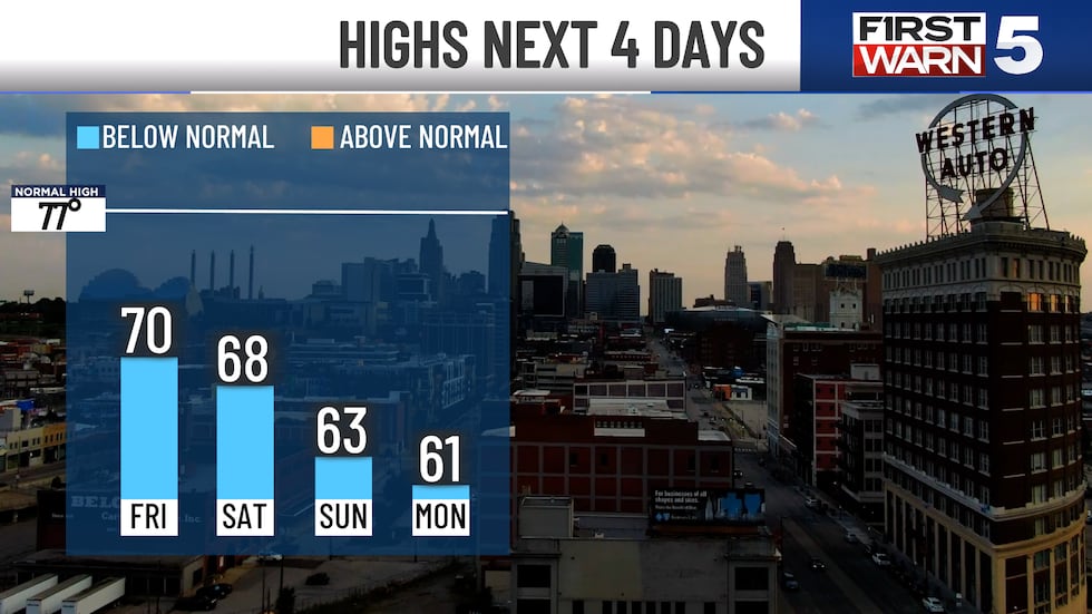
High temperatures reach 70° once again. Skies will generally remain mostly cloudy,
SATURDAY: First Warn Friday for two rounds of rain and storms. The first will be in the morning (continuation from Friday night) until about 10 a.m., and then again around dinner and into the night. This second round will bring another low-end severe weather risk (level 1/5) for the southwestern half of the area. Damaging winds, hail, and heavy rain are the primary threats. The good news is there should be a nice break during the day. However, it will be cloudy and cool in the upper 60s.
SUNDAY: First Warn for rain at times again Sunday. The morning will be the wettest part of the day, and may be fairly widespread and heavy. It looks to clear out for the afternoon with mostly dry conditions, cloudy skies, and highs in the mid-60s.
MEMORIAL DAY MONDAY: NEW FIRST WARN: Rain chances have bumped up to 40% and will be scattered in nature, mainly through the first half of the day.
Another big story is the unusually cool weather. Highs in the low 60s would be about 15 degrees colder than normal. In fact, high temperatures will take a run at the record coldest of 62° set in 1997. Plus, it will be one of the coolest Memorial Days in over 30 years!
FLOODING CONCERNS: When it’s all said and done, we could see quite a lot of rain from this system. Flood Watches are in effect Friday evening through Monday evening for our southern areas. Our southern areas could see 1-3″ of rain with isolated areas of 4″ possible. Along I-70, and in the metro 1″ to 2″ are possible. An inch or less for those north.
REST OF NEXT WEEK: We finally start to see the sun and warmer temperatures after Memorial Day! Highs warm from the upper 60s to the mid-70s. However, we can’t quite shake the rain just yet as low-end chances are possible through the week.
To get the latest weather updates sent to your phone, the KCTV5 Weather app here.
Copyright 2025 KCTV. All rights reserved.


