First Warn Forecast: Back into the 70s this afternoon, First Warn this evening
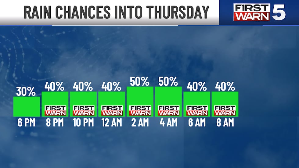
KANSAS CITY, Mo. (KCTV) - We warm up this afternoon with high temperatures near 70°. A First Warn is in place for scattered rain and storm chances around 7 p.m. this evening into 9 a.m. Thursday. There is no severe weather threat.
Temperatures make it into the low to mid-60s by lunch with partly cloudy skies. High temperatures will be warmer, hitting around 70°. By 4 p.m., we turn our attention to some rain and storms.
Isolated activity is possible between 4 - 6 p.m. It becomes more scattered with a First Warn by 7 p.m. and will continue into 9 Thursday morning. The best chance is after midnight, mainly along and south of I-70. Those along and south of I-70 may see a quarter to a half inch of rain. Higher amounts are possible along our southern border.
THURSDAY: The First Warn will come to an end by 9 a.m. Thursday, but spotty pop-up showers and thunderstorms are possible across the area Thursday afternoon and evening. Expect a lot of dry time throughout the day with partly cloudy skies and high temperatures around 70°.
WEEKEND: A big warm-up and more sunshine are on the way for the end of the week! High temperatures on Friday reach the upper 70s (still slightly below average). The low to mid-80s return for the weekend with a 20% chance of rain.
NEXT WEEK: The start of next week is even warmer with highs in the mid-80s. We will stay dry on Monday with mostly sunny skies. A 30% chance of rain and storms returns on Tuesday.
To get the latest weather updates sent to your phone, the KCTV5 Weather app here.
Copyright 2025 KCTV. All rights reserved.


