First Warn Forecast: Severe storms move out of Kansas City area
KANSAS CITY, Mo. (KCTV) - UPDATE: 3:32 p.m.: A Severe Thunderstorm Warning has been issued for Missouri cities Marshall, Sweet Springs, Malta Bend and their surrounding areas until 4:15 p.m.
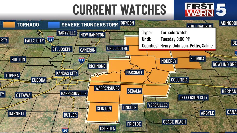
Update: 4:30 p.m.: A majority of counties have been removed from the tornado watch; only a few eastern counties remain as storms are moving through that part of the KCTV viewing area. The KC metro has been removed from the tornado watch.
A Tornado Warning has expired for parts of Johnson and Miami counties in Kansas and the Blue Springs, Independence and Grandview areas of Missouri.
A Tornado Watch is in effect until 8 p.m. for the following Missouri counties: Jackson, Cass, Ray, Bates, Johnson, Carroll, Saline and Pettis.
A Flash Flood Warning is in effect until 7 p.m. for much of Johnson County, Kansas, and Clay and Jackson counties, Missouri.
As of 2:40 p.m., Evergy had listed about 5,000 customers in the Kansas City area as being without power.
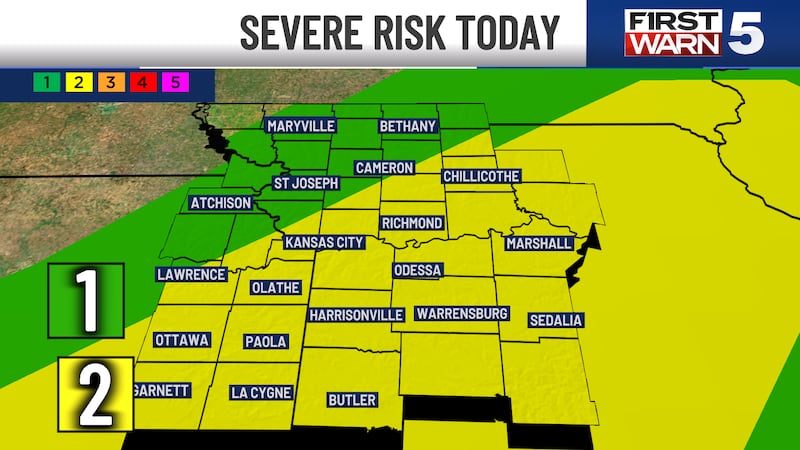
A wet day is expected, with a Flood Watch in effect with more rain and thunderstorms into the afternoon. There are even a few pockets of stronger storms possible, however, the higher risk for severe weather has shifted to the east out of the KC metro. Regardless, noisy scattered storms are expected through the heart of the afternoon.
The afternoon round is expected to pack a punch for some. Heavy rainfall, damaging winds, and hail are the primary threats today, there is a low tornado threat. The biggest concern at this time is flash flooding. There already have been reports of water rescues in Anderson County, east of Garnett. Multiple more inches of rain are possible through the evening, so flooding will likely be a concern for the remainder of Tuesday. These storms will likely form ahead of a cold front. That front will sink through the area from 2 p.m. to the late evening.
Rain still lingers in the southeastern quadrant of the area tonight, but it will be cleared by the time we wake up on Wednesday.
A Flood Watch is in effect from 7 a.m. Tuesday to 7 a.m. Wednesday, as we could see widespread rain amounts of 1″ to 3″ when it is all said and done. Isolated higher amounts are possible.
Temperature-wise, it’s a warm morning with temperatures in the lower to mid-70s. Interestingly enough, our high temperature today will occur this morning and will fall throughout the day. The cold front moves in this afternoon and drops temperatures. By 3 p.m., temperatures will be in the mid to upper 60s.

WEDNESDAY: Partly cloudy with highs in the mid-70s.
THURSDAY: Pleasant with highs in the mid-70s. A few spotty showers and storms are possible, rain chances are 30%.
FIRST WARN FRIDAY: Scattered rain likely in the morning, but trending drier for the afternoon. Highs will be in the upper 70s.
WEEKEND: Highs in the upper 70s and low 80s. We have low rain chances at 20% for Saturday and 30% for Sunday.
To get the latest weather updates sent to your phone, the KCTV5 Weather app here.
Copyright 2025 KCTV. All rights reserved.