FIRST WARN FORECAST: Much nicer Wednesday, Friday brings next First Warn
After record rain in Kansas City Tuesday of over 2.5″ at KCI (which is about a half month’s worth of rain in just one day), we are looking at much nicer weather Wednesday. Spotty rain is possible Thursday, but Friday could bring heavier rain in the morning and is being flagged with a First Warn.
TONIGHT: FIRST WARN - Continued rain, heavier south of Kansas City. Temperatures in the 50s.
WEDNESDAY: Much nicer! Pleasant morning with 50s and mostly sunny skies. The afternoon will bring mid-70s and light northeast winds at 5-10 mph.
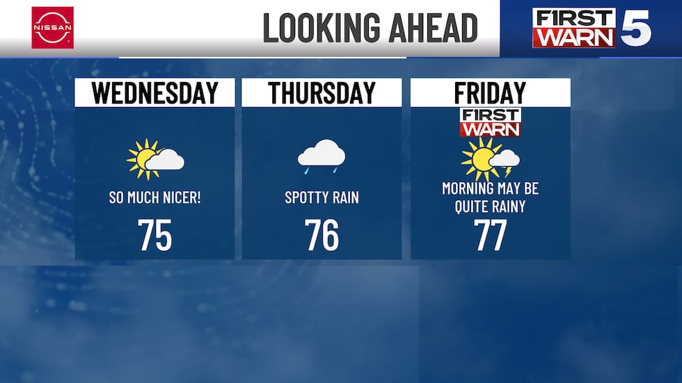
THURSDAY: Spotty showers possible near lunch and for the early afternoon. Highs in the mid-70s with mostly cloudy skies.
FRIDAY: FIRST WARN - The morning may be quite wet, though we look drier for the afternoon. Highs in the mid to upper 70s.

THE WEEKEND: Warmer with highs near 80. Saturday is mainly dry with just a 20% rain chance. Sunday has a slightly better chance for rain, with the highest odds being in the afternoon and evening.
Copyright 2025 KCTV. All rights reserved.