Quiet but hazy day with a First Warn looming for Friday
KANSAS CITY, Mo. (KCTV) -It’s the calm after the storm, and seasonally cool air has filtered into the region. Winds are now from the north/northwest and will funnel in some wildfire smoke and haze into our area. Otherwise, we will be on the dry side today, but rain chances return Thursday with a First Warn Friday.
We will see partly to mostly sunny skies through the mid-morning to lunchtime hour but keep in mind we will likely have that wildfire smoke around. Most of us will be dry but the southeast could still see some isolated showers throughout the day as the large system pushes off to the east.
By lunchtime, temperatures will warm to around 70°. High temperatures will be several degrees below average in the mid-70s. We do have a 20% chance of seeing an isolated pop-up shower between 5 -7 this evening. Otherwise, it should be a mainly dry for most, just on the hazy side.
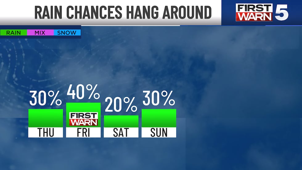
THURSDAY: Spotty showers are possible near lunch and for the early afternoon. Highs in the mid-70s with mostly cloudy skies.
FRIDAY: FIRST WARN - Scattered rain and thunderstorm activity will be possible on Friday, mainly in the morning. We do look drier for the afternoon. One or two storms may become strong along the southern border, but the severe threat is to our south. Heavy rainfall is possible. Highs in the mid to upper 70s.
THE WEEKEND: Warmer with highs near 80°. Saturday is mainly dry with just a 20% rain chance. Sunday holds a slightly better chance for rain in the afternoon and evening.
To get the latest weather updates sent to your phone, the KCTV5 Weather app here.
Copyright 2025 KCTV. All rights reserved.